Last month Cary and I went on a fall backpacking trip. To be honest I had a furlough day so it was a perfect time for a mosquitoless backpacking trip. Friday night we drove up to Mammoth where we stayed the night at a Motel 6. Once we arrived at our motel we had to come up with a game plan for our backpacking trip. Our original plan was to hike the 1,000 Island lake area via the River trail. Unfortunately Mammoth got hit with 19 inches of snow during a midweek snow storm and closed the road to the trailhead. After looking at a map we decided to try the Gem lake area out of June lake. The next morning we woke up and went to the ranger station in Mammoth to change our plans. After a few hours for breakfast and driving we arrived and started hiking the Rush creek trail by 11.
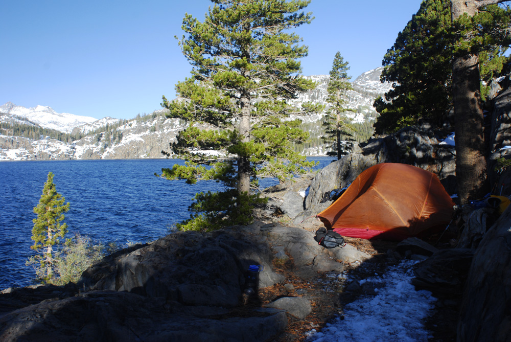
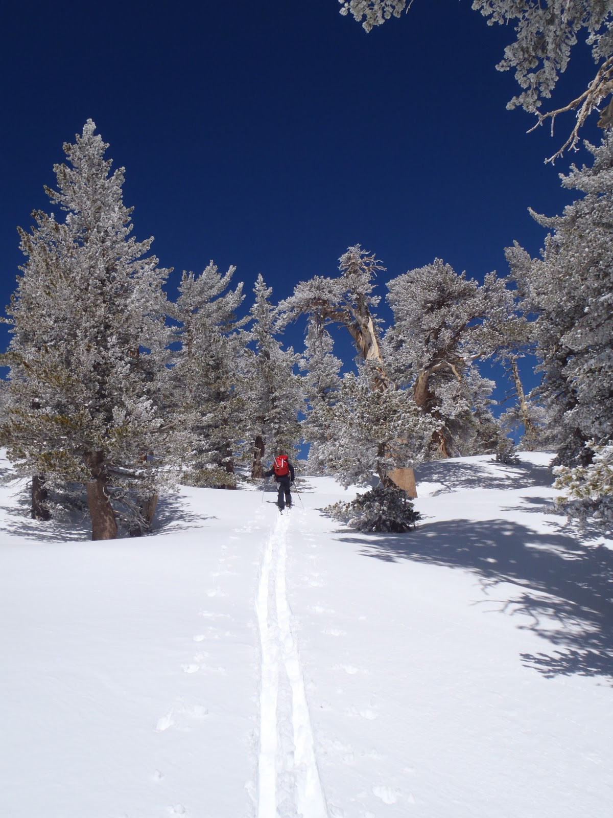
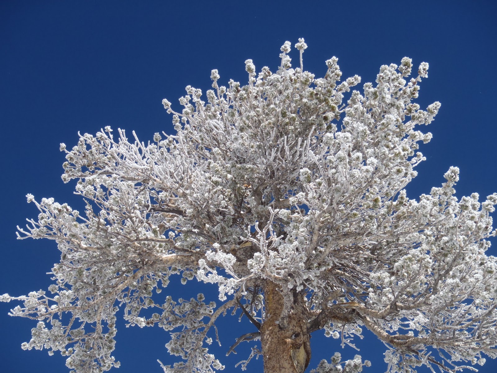
Before we set out hiking we didn't know how the snow conditions were going to be. We left the crampons behind and brought the snowshoes just in case. After a few hours of hiking and tramping through snow (not enough to put on snowshoes, just gaitors) we arrived at Gem lake (3.5 miles from the trailhead). The lake was absolutely beautiful with snow covered mountains all around. It was hard to find a place to camp since the flat ground was covered in light snow. We ended up shoveling off a thin layer of snow to set up our tent. The rest of the afternoon we went exploring around the lake. At night we focused on night photography. It was a great night to shoot, a cloudless sky with a bright moon made our 10 minute exposures look like it was the middle of the day minus some faint start trails.
The next morning we woke up late, shot some more and then headed out to Waugh lake. After a mile and a half of trekking through snow we got to a point where we had to break trail in deeper snow. This made hiking slow going. After a mile or so later I began to feel lightheaded and ill. This usually happens because I don't eat enough and my blood sugar drops. We stopped for lunch on top of a hill where we could see both Waugh and Gem lake. Incredible! After lunch I began to feel a lot better but still pretty tired. We decided to head back and meander around Gem lake. When we trekked back to the lake we found a meadow of aspen trees along the shore. We got our cameras out and spent the next hour or so shooting the aspens with the snow capped mountains in the background. We arrived at camp in the late afternoon. After filling up some water and eating an early dinner we got out our cameras and tried our best to capture the night landscape of Gem lake.
The next morning we woke up and ate our smores poptarts and headed back to the parking lot. Hiking back was a lot easier since it was mostly down hill and lots of the snow on the trail had melted. The trail was a little steep. It was about a 2,000 feet elevation gain from the trailhead to Gem lake. The days were about 60 degrees and the nights were cold, around freezing. Overall the trip was great. It was one of the more scenic trips we have taken. The snow covered mountains really was a treat, even though it slowed us down it made for great backdrops in our photographs!
Last weekend Cary, Erik (my brother), and I went backpacking in Yosemite. We headed out via White Wolf campground on Friday afternoon (3pm) towards the 10 Lakes area. Since we had a late start and due to the high altitude we set up camp 2 miles shy of 10 Lakes near Half Moon Meadow. Once we found a place to camp we set up tents and ate dinner as fast as we could trying to avoid getting bitten by the infinite amount of mosquitoes. The next morning we got up packed up our camp and headed to 10 Lakes. After 2 hours we reached the top of the ridge just above the lakes. We decided to camp up high since photo ops would be better up top instead of in the deep valley with steep cliffs. Our campsite was awesome; it overlooked the grand canyon of Tuolumne and the 10 Lakes area. After setting up camp we packed up daypacks and hiked down to the lakes to spend the afternoon exploring. Once we were down there we photographed the lakes, waterfalls, streams, and mountains. Erik was also brave enough to jump in the lake, which was very cold. I had a great time using my new neutral density filter, which enabled me to shoot water blur in direct sunlight. After a few hours we headed back up to the top of the ridge to our camp and enjoyed dinner and shooting sunset. The next morning we got up around 5:30 to shoot sunrise and then packed up our camp. Heading back we exited the 10 lakes trail instead of hiking all the way back to the White Wolf campground. We left Erik’s car on Tioga road near the 10 Lakes trailhead so that we could shuttle back to my car at White Wolf. Sunday’s hike back from the 10 Lakes ridge to the car was mellow and mostly all down hill. It only took us about 2.5 hours to get down.
Start: Friday Aug 5th, 3pm @ White Wolf Campground
After Deer Mountain (see previous post) we decided to try to climb something that had less trees and a run out all the way to the car (meaning we can ski all the way back down to the car). In Crowley, just south of Mammoth we decided to climb the Hilton Creek Trail. We skinned up and trekked up a slight incline for about .6 of a mile. After that we began a more steady climb. After climbing 1500 feet and 1.5 miles we decided to ski down. The snow conditions were not great. The snow was punchy and warming up creating some unexpected deep spots. We had to ski with caution because we didn't know when the thin crust was going to give. Looking back on it we should have started a lot earlier to avoid mushy snow. Skiing down was still fun. Unsure of whether we could ski all the way back to the car we bombed the last hill to carry momentum. Surprisingly we were able to ski all the way back down. It was long and it destroyed my legs but it's a lot better than skinning back to the car!!!
The next day we got an earlier start and climbed Hilton Creek Trail again. This time the snow was firmer and more enjoyable. I got to say it's a great place to bc ski. I love it and the run out all the way to the road. It offered beautiful views, nice slopes, and not too many trees. And of course we didn't see anybody around us both days. Good times. Next time we are in Mammoth we will definitely do this again and hopefully climb a little higher.
Last weekend Cary and I went up to the Mammoth area to do some back country skiing. The first day we headed out to the Inyo Craters and to climb Deer Mountain. We parked just off scenic drive and skinned up to the Craters. It was relatively flat for the first 1.5 mile trek. After viewing the craters we climbed Deer Mountian which is right next to the craters. It wasn't a long or steep climb but it was good practice climbing with skins on and it offered incredible views from the top. When we reached the top we realized there was 3 high points which made it hard to dicipher which one was the actual summit so we tagged all three:)
On our decent down it was slow going. The snow wasn't in good condition, soft with a little bit of crust and there were lots of trees to avoid. Nonetheless it was fun and challenging.
Stats:
Total Mileage: 4.2
Start 10:00
End 3:30
Note: The first mile was kind of boring since it was a relatively flat. I prefer to be ascending or descending on skis.
Last week I purchased a Go Pro Camera to use during my outdoor adventures. I couldn't wait to try it out surfing. On Monday and Tuesday I went surfing at 11th street in Del Mar and even though the waves weren't great it was still a ton of fun. Take a look!
I mounted the camera to the front of my single fin 7'4'' funboard.
Last week my buddy Justin and I went skiing at our near by ski resort Mt. High. This season I am learning how to ski because I am getting into backcountry skiing. I am trying to get as much experience on skis as possible this season, on groomed runs and in the backcountry.
Props to Cary for getting a picture of me on my feet!
Cary and I had such a blast 2 weeks ago at Snowcrest we decided to go back and ski some of the different more challenging runs. On our drive there, 3 miles from the Snowcrest area we encountered 3 cones blocking off the road. Hmm, the road looked perfectly fine to us. After little debate we decided to drive around them and check out why the put the cones blocking the road. About a mile down we quickly found out. Snow! The road had not been cleared/plowed. Last week a storm dumped about 5 feet of snow on the area and the snow plow only cleared Hwy 2 up to Waterman ski area, which is 3 miles from Snowcrest.
Cary and I dumped our gear off at the end of the road where it met the snow. We drove back to the cones and parked the truck. We walked down the road and skinned up our skis and toured the last 2 miles to the Snowcrest. It was an unexpected detour but it was good practice skinning of flat surfaces. A little over an hour and a half later we arrived at Snowcrest (a deserted ski area). We had a blast last time we were here and we thought it would be even better due to the recent storm. It was nice to see the place completely blanketed with a good 4 feet of snow. But unfortunately the skiing conditions were not so great. There was a semi hard crust as the top layer and then about 4 feet of very soft snow below it. We found this out when Cary dug a pit to perform an avy test. While skiing our skis sank in just a little to feel like they were stuck in grooves. I took many spills coming down because I felt my skis were stuck in a rut or something. Cary even did a face plant (on much steeper terrain) as well which made me feel a little better. It was frustrating eating crap left and right when just 2 weeks ago I was skiing the same runs much better. Oh well, as Cary says "a bad day in the mountains is always better than a day of work!"
After a few hours at Snowcrest we toured back to the end of the plowed road where we put our gear on our backs and walked the last mile. Even though it was a frustrating day it was still fun. There were beautiful clouds covering the snow capped mountains and other than running into 2 snowshoers on the snow covered road we had the place all to ourselves.
**I purchased a helmet camera with my REI dividend. Unfortunately most of the footage I recorded was me eating it:-) Once I get better at skiing it will be awesome to use! I plan to attach it to my surfboard as well and start posting some of my surf sessions too!
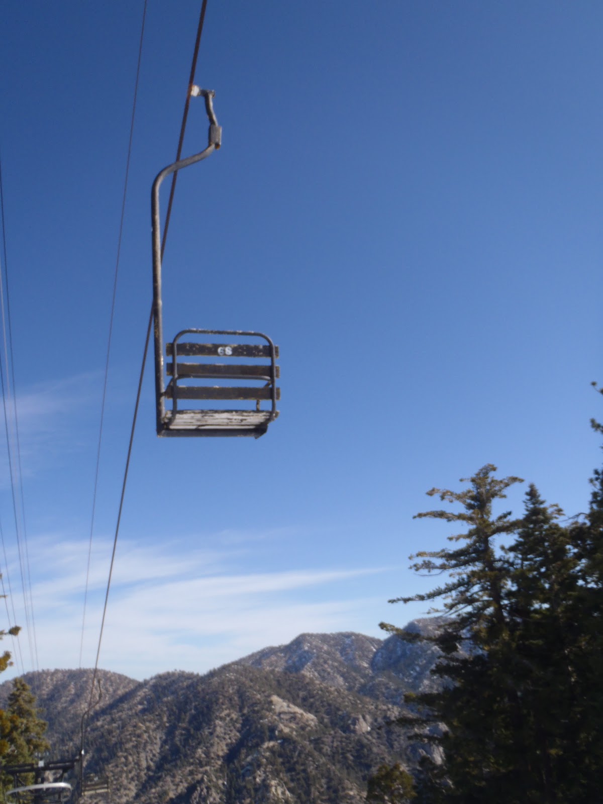
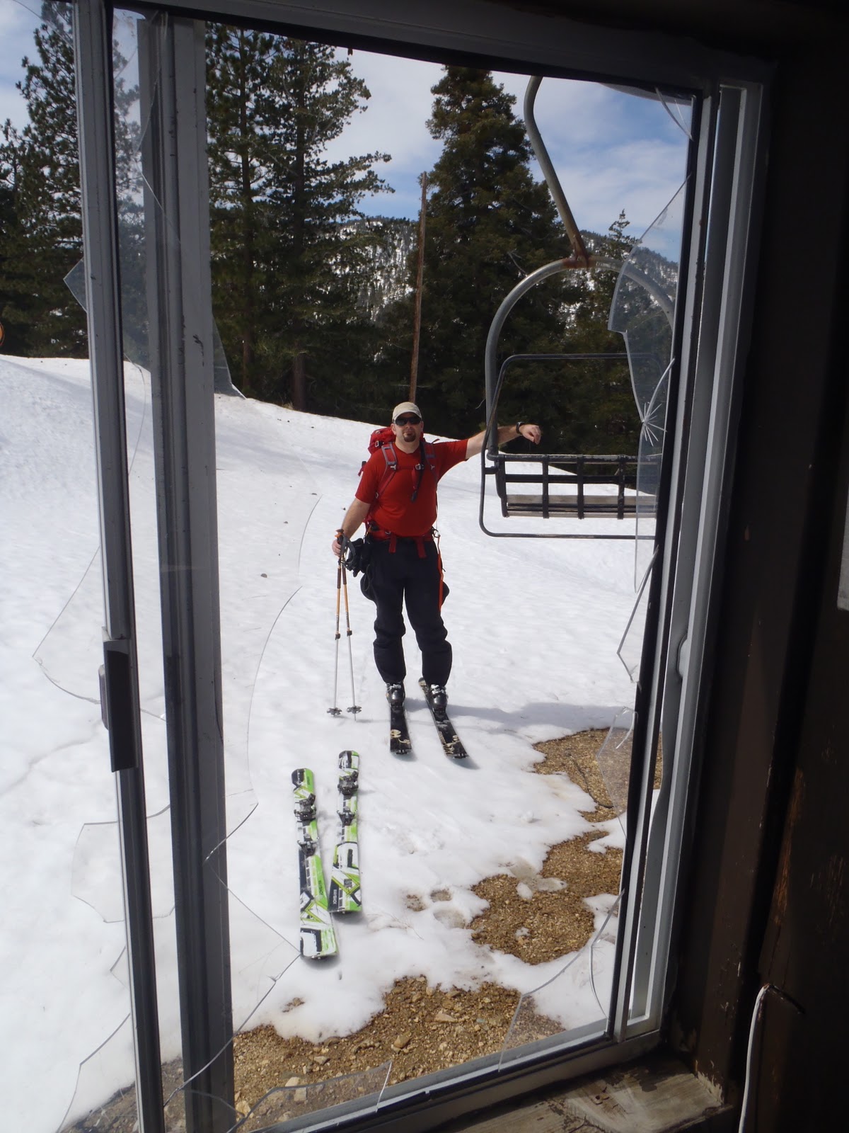
Last Saturday Cary and I skied the old, abandoned ski resort of Snowcrest also known as Kratka Ridge. Snowcrest is just a couple miles down from Mt. Waterman in the San Gabriel Mountain Range. We started climbing up the old ski runs and were quickly intrigued by the rustic feel this old resort had to it. The runs were in decent shape with a few new trees popping up, but the thing that was really interesting was seeing the old run down chairlifts and operating booths. Windows were smashed out, wires were pulled out, a little graffiti, and some of the roofs were caved in. Snowcrest is also home to the single chair lift, which is one of only two in the US.
Cary and I climbed up the ridge about 700 feet and found the summit register. Yay, our first ski climb summit! Yes, I know it's only 700 feet but I'll take it. After taking in the scenic views and exploring the abandoned ski lifts we took off our climbing skins and prepared for some down hill skiing. We skied down a blue diamond run that had some new trees popping up. The snow was still icy and made for fast skiing conditions compared to the fresh powder on San Jacinto. Cary being very patient and helpful helped pick out lines for me to ski down. I am getting more and more comfortable on skis and want to push myself to ski steeper slopes. This run was a little steeper than San Jacinto and I looked forward to the challenge. The first half of the run was steeper than the second. I fell a few times and got frustrated by my slow and inconsistent path down the mountain. After the first section I got a better feel for turning without relying solely on snow plowing. Cary and I climbed the mountain 2 more times and I skied the entire mountain much more comfortably and confidently. I think I only fell one more time and picked up my speed as well.
Skiing Kratka Ridge was an absolute blast! We had the ski area all to our selves except for one other backcountry skier we saw at the end of the day. I can't wait to get back out there and try some of the other runs, hopefully a little more challenging, but not too crazy!
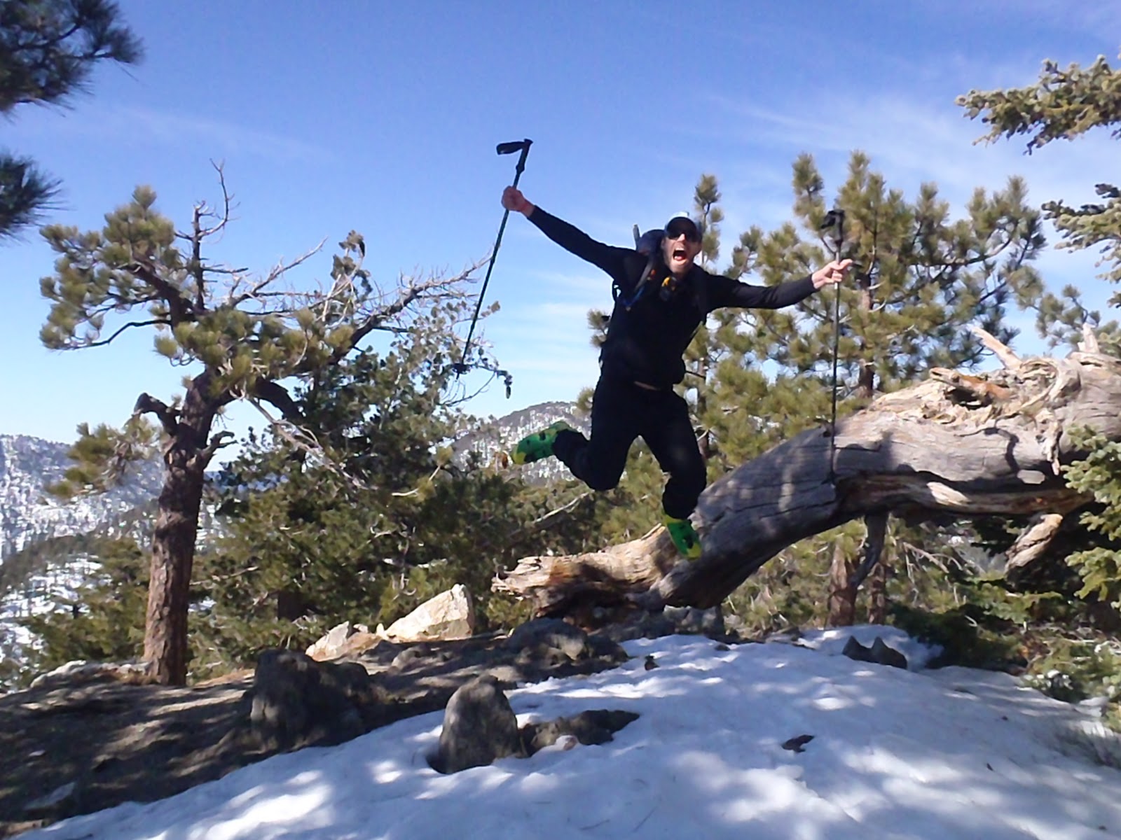
Jump for joy!
Rare: A single chair lift
Old ski lift
No I didn't jump through the window
Upper section of the mountain.
Our first ski mountaineering summit....yes it was only 700 feet but who cares:-)
Last Sunday Cary and I went to Palm Springs to climb/ski San Jacinto Peak. This season Cary and I are getting into backcountry/ski mountaineering. Traditionally we've been climbing with snowshoes and crampons. After witnessing bc skiing we quickly came to the conclusion that it would be much more enjoyable skiing down a peak then slogging down it in snowshoes. Cary is a great skier, however, I am not. I am learning how to ski/bc ski all at once, this is why I move so slow in the videos. Cary has been very patient with me and has been giving me great advice. Slowly but surely I am feeling more comfortable on skis.
We took the 8am tram up to Round Valley. Around 8:45 we were all skinned up and started climbing. The first mile and 500 feet of elevation gain was a narrow trail that was kind of hard to skin up. We were dodging trees, branches, and leap frogging hikers in snowshoes. Once we reached about 8,900 feet the trail opened up and we could climb straight up (for the most part). This is our second time climbing with skins on and our first major peak/climb. We were pretty slow going trying to get the hang of skinning and managing our gear. At 10,400 feet we reached the top of the ridge (400 feet from the summit). Cary's new boots where beating down on his feet and my blood sugar dropped too low. We decided to take lunch on the ridge and then ski down.
Skiing down was absolutely AMAZING! Fresh powder made for spectacular skiing. Cary said it was some of the best powder he's ever skied, that's pretty good for a life long skier! We skied down about 1,500 feet. I fell 2 times once burying my face in the snow (see the video). Once we got down to 8,900 feet we grudgingly took off our skis, put them on our backs and hiked back to the tram. The last mile was long and a pain in the butt but we didn't have an alternative. When we got back to the ranger station we returned our permit, talked with a split boarder and waited in line for the tram. Our feet killing, we eventually made it back to my car.
We really enjoyed our first real climb. We still have plenty of work ahead of us though. I need to become more efficient climbing up with skins. It would also be nice to find climbs/peaks that we could ski all the way back down to the trail head instead of hiking out with our skis on. Oh well, I guess it's good for us. I must say ski mountaineering is exhausting. I hope it becomes easier the more we do it:-)
Mel rocking her 7'4'' fun board and her new wetsuit
Yesterday Melis and I went to a surf-shop to buy her a wetsuit. Yup, that's right, Mel is going to start surfing! Yahoo! While we were there we also found a 7'4'' fun-board that was being sold on consignment. Since the price was right, we decided to get it. I'm not going to lie, I'm excited to use the fun-board as well:-)
Today Melis and I went to El Porto in Manhattan Beach to test out her new gear. The waves were pretty small and just right for learning. Melis did a great job on the single fin fun-board. She got up and looked very comfortable wearing her new 4/3 wetsuit. When learning how to surf it's important to get out as much as you can. So I hope to take Mel out a few times next weekend. Before I know it she'll be ripping Sunset and Surfrider on her way back from work at Pepperdine. Good times.
Last week I flew up to Mammoth to meet up with Cary to try out "at skiing" and my new gear. Both Cary and I have decided to take up backcountry skiing/mountaineering. Yes, we have a LONG way to go before we attempt anything serious. First, I need to learn how to ski. Luckily, Cary is a good skier who is more than willing to give me tips. Regardless I plan to get use to skiing and touring on the skis over the next few months. After this trip I quickly realized I need to purchase a helmet, there are just too many trees around!
On Friday we headed up to the Obsidian Dome area just north, off the 395. Marking our first "at skiing" experience we traveled about 4 miles climbing just a hair over 500 feet. It was slow going at first getting use to hiking in skis. After a while we slowly but surely started to get the hang of it. One person led while the other followed in their tracks. Around 3:30 we arrived back at the truck and we headed back to the Mammoth area. Since we didn't climb any hills to ski down we decided to find a mellow hill off the road to climb and ski down. Off the Scenic Road near Mammoth we found our spot. We climbed up a few hundred feet, took off our skins (which enable us to climb up hill) and skied down. I quickly learned that I really need to spend a few days at a ski resort to practice my skiing, just getting the general technique down. Anyway, it was still a ton of fun.
On Sat we headed out to the Tamarack side of Mammoth. We skied to the old mining shafts near Lake Mary. On our way, we found a great place to practice our down hill skiing. It was also nice to get the practice of taking off and putting on our skins. After the 6 mile trip we headed back to town. We both really enjoyed our first "at skiing" experience. I'm relieved considering I've spent a ton of money on my set up! Over the next few weeks we plan on doing day trips whenever we get an opportunity. Then by April or May we will attempt to climb a somewhat mellow peak.
Last weekend my best buds from elementary school and I went skiing at Badger Pass in Yosemite. We drove up Saturday to Tenaya Lodge where we stayed for 2 nights. On Sunday we piled into my jeep and drove about an hour to Badger Pass. Luckily we didn't need any chains. When we got there we picked up our rental gear that we ordered from Tenaya Lodge the night before. This was especially nice since we didn't have to wait in any lines.
Around 10:30 we were on the slopes skiing. Now, just to put some perspective on this trip, we haven't skied in about 15 years except for Gabe who has been shredding on a snowboard for a few years now. Badger Pass is small, they have 3 different levels of skiing; green, blue, and black. No double black diamonds here. Over the next 6 hours we skied all the runs enjoying the nice 60 degree weather. We had an absolute blast, it was super mellow and a good way to transition back into skiing. This trip was so much fun that it cemented an annual ski trip amongst the 4 of us. I wonder where we'll end up next year?!