Tuesday, December 23, 2008

Mt.Baldy...Climbing in the snow.


On Sunday Katie, Cary and I set out to climb Mt.  Baldy.  A few days before a storm dumped a few feet of snow on the mountain.  We started around 7:40 and decided to hike the Ski Hut route, a steeper more direct route to the summit.  We all had our ice axes and snow shoes packed and headed out.  There was a ton of snow on the trail.  At 9:45 we reached the ski hit.  We took a 10 minute break and then discussed the route we wanted to take up to the summit.  Normally, we would follow the traditional route that winds around the face of the mountain and up the ridge, however, today since there was so much snow we decided to follow a few climbers that were climbing up the right side of the face of the mountain.  It was definitely steeper than the traditional route.  Luckily the snow was punchy which made climbing without crampons alot easier.  Climbing up the face was extremely fun and exciting, it was not a viable route unless there was a ton of snow.  It took us another 2 hours and 20 minutes of steep climbing to reach the summit.   The views while climbing were absolutely breath taking.  Once we got to 9000 feet we could see the desert beyond the Devils Backbone, we could also see San Gorgonio and San Jacinto.  We reached the summit around 12:30.  It was pretty cold at the top so we bundled up with layers quickly.  After taking about 15 minutes to eat lunch we headed back down.  We were able to glissade a little bit but mostly post holed all the way back down to the ski hut.  At the hut we put on our snow shoes and headed back down the mountain.  There was so much snow that we were able to snow shoe off the beaten path which made hiking back more enjoyable.  We finally reached the parking lot around 4.  After climbing all day we were excited to go grab some food, however, it took us an hour and 15 minutes just to get down to the base of the mountain due to terrible traffic.  

This was one of my favorite climbs I have ever done.  This was great training for Rainier in June and I am sure I'll be doing this alot more in the near future.

Start:7:40 Manker Flats
Skit Hut: 9:45
Summit: 12:30
End: 4:00
Elevation Start: 6100 ft
Summit: 10064 ft
* the "our route" picture was taken at the Ski Hut


Thursday, December 18, 2008

Let it snow! Let it snow! Let it snow!


Today after work I couldn't resist the temptation to hike around in the newly fallen snow off Angeles Crest Hwy.  After work I drove up Hwy 2 to the Grizzly Flats Trailhead.  I got there around 4 so I only had about 30 minutes to hike around.  The snow was coming down and the wind was picking up.   On my way back they started to close the Hwy 2 to on coming motorists.  It was about 32 degrees out with only a handful of people.   I got a chance to hike in my new La Sportiva boots, which are awesome....so far.  This storm has dumped a ton of snow and has got me excited to climb Mt. Baldy Sunday.  

Monday, December 15, 2008

Strawberry Peak (San Gabriels)


 Today Cary and I climbed Strawberry Peak (6,164 feet) in the San Gabriel Mountain Range.   We were hoping for a storm to dump snow on us but it was all clear skies.  We are currently training for Mt. Rainier, I have started running and doing stairs and now we are starting to hike on the weekends.  This hike was mellow.  We parked at the Red Box parking lot and crossed the hwy 2 where the trail begins.   The hike was relatively flat for the first 2.3 miles and then the last mile got steep where most of the elevation was gained.  Next week Katie, Cary and myself are going to climb Mt. Baldy.  There is a big storm rolling in this week so I think we will be climbing in snow....can't wait!

Start: 7:30am
Return: 11:30am
Elevation Gain: 1500 feet
Conditions: 50's and sunny
Total Mileage: 6.6 miles

Wednesday, October 29, 2008

Zion National Park


Recently Cary and I drove to Zion National Park to take some photographs of the beautiful fall colors.  It was a long 8 hr drive but well worth it.  We took of Friday afternoon and got in late.  We slept in the car at the visitor's center(all the campsites were full).  In the morning we shot at the emerald pools, which is a short hike from the Zion Lodge, later we took the tram up to the Narrows.  The Narrows are awesome.  In the Narrows you are en golfed by huge walls and water ranging from your ankles to knees.  There are sand bars scattered about that makes walking easier at times.  The giant copper colored walls are spectacular.  We did alot of motion blur with the walls in the background.  Half the shots I took were in the water.  I was usually shin high with my tripod legs in the water.  At sunset we drove just outside the park and found trees with a wide variety of fall color leaves.  We planned to come back in the morning when the light we better.  That night we ate at a place in town called pizza and noodles ( or something close to that).  I do not recommend it, the burnt the hell out of my pizza.   That night the ranger told us about a free campground exactly 7 miles outside the park so we spent the night there.  The next morning we woke and shot until 10.  The colors were great just outside the park(at higher elevations).  From there we made the 8 hr treck back to Los Angeles.  After sifting through my photos of the trip I got about 3 or 4 winners.  None of my fall colored trees turned out well.  My favorite shot is a water blur from the Narrows.  I absolutely love the landscapes and fall colors of Utah. 

Good times!

Wednesday, October 15, 2008

Mt. Rainier - June '09 Baby!!!!!!!!!!!!!!!!!!

So it is set. I am climbing Mt. Rainier in early June  '09.  I will be climbing with my close friends Dave, Cary, and Katie.  I can't wait it should be a ton of fun.  I haven't climbed with a big group of friends before.  We are climbing the traditional Muir route.  We are climbing with RMI Guides.   I plan to start training in mid Nov.  It is easier for me to exercise when I am training towards a climb.  

Good times with good friends!

Note:  This is my first big climb out of state.   Do you think the airlines will let me carry on an ice axe?  

Friday, August 22, 2008

Channel Islands - Santa Cruz - Scorpion Bay


On Tuesday my buddy Jeff and I went to Santa Cruz Island ( part of the Channel Islands off the coast of Ventura) to camp, kayak, free dive, and hike.  We took a boat through Island Packers Company over to the island (about an hour away).  In order to camp I had to reserve a campsite (no first come first serve) through the national park system.  

So on  our way over we saw about 100 common dolphins jumping and playing in the wake of our boat.  This was incredible, dolphins jumping and playing all around the boat.  This was just one more added bonus to the camping trip.

When we got to the island we unloaded our gear and kayaks (they transport personal kayaks for 14 bucks) and headed to our campground.  I reserved site #11 which is a little more removed from the rest of the campsites, sites 2 and 14 are also good sites to have.  It was only about a 10 minute walk to our campsite where we set up our tent and then went back to the bay to go kayaking.  Jeff and I put our snorkel and fins in our kayaks and headed north around the bay, going in and out of caves.  These caves were amazing, and the swell was mellow which allowed us easy access through them.  After about an hour of kayaking we found a remote place to beach our kayaks and go snorkeling.  We snorkeled for about 40 minutes.  The visibility was 15-2o feet.  We saw an array of sea life, pink abalone, Garibaldi, starfish, sea slugs, bat rays, lobster, an assortment of fish, anemones, corral, a small shark (type...I forget) and my favorite a friendly seal.  The seal hung out with us just about the whole time we were diving.  They are very playful creatures, the seal swam above, below and to the side of us.  The seal got within 2 feet from my face and started to play with my fins.  After we were done diving we had to say good bye to  the seal and kayaked back to Scorpion Bay.

When we got back to our campground we traded in our kayaks for our hiking shoes and took a hike up to Potato Cove and Cavern Point.  This hike followed the cliffs of the island making for great pacific views.  Upon returning to our campsite we made dinner and had a few tasty beverages (Steel Reserve......thanks Jeff! :-).  Once the sun went down we headed back to the bay and checked out the moon.  I have never seen the moon rise over the ocean like this.  Looking east towards Los Angeles an orange glow appeared.  A few minutes later a bright orange(almost full) moon started to rise.  It was awesome!

The next morning we slowly woke up and put on our somewhat dry wetsuits and kayaked down the southern edge of the island.  After and hour or so we headed back and kayaked back north of the bay.  We went to a different cove that didn't have a good place to beach our kayaks so we tied them to some kelp and dove off our kayaks.  Personally, I enjoyed diving and kayaking north of the bay rather than the southern edge.   That morning our friend the seal was not around but it was still great to go diving.  After about 3 hours of being out we returned to our campsite and rested and waited for the boat to pick us up around 4.   We were pretty beat from the kayaking and diving and didn't have much energy to do anything more than chill.  On our way back on the boat we saw more dolphins jumping and playing next to the boat, which is always nice.  

All and all it was an awesome trip!  My buddy Anneke who suggested this trip was right.  This was definitely a great get away that is affordable and doable in a weekend.  Camping is 15 dollars a night and the boat transportation is 64 dollars plus 14 for a kayak.  Note, if you want to bring a kayak you need to reserve a kayak spot on the boat.  Island Packers can only reserve about 14 each trip.  So don't make your camping reservation before your boat reservation.  Go online check the availability of campsites, then call Island Packers reserve tickets and then reserve a campsite. 

Links:
Camping Reservations:  Scorpion Bay - Santa Cruz
Island Packers: Boat Transportation

Note:  It is super chill camping, nice bathrooms and clean drinkable water.  
If camping isn't you idea of fun you can take a boat over to the islands in the morning and return in the late afternoon.


Wednesday, August 6, 2008

Horseshoe Meadow Backpacking


This trip was originally suppose to be a Mt. Langley summit climb but soon faded to a leisurely backpacking trip.  I signed up with the Sierra Club to do this climb.  I also needed this trip in order to graduate WTC (the wilderness class I took last winter).   I was excited to do this trip as one of my goals is to climb all of California's 14,000 foot  peaks.  Unfortunately, the Sierra Club trip was misrepresented in labeling the trip as a Mt. Langley climb.  It should have been labeled a leisurely Cirque Peak climb, which is 12,900 feet.  

Thursday:  Drove up to Horseshoe Meadow (Golden Trout) parking lot and spent the night in the car.
Friday:  I packed up my gear and met up with the 2 Sierra Club leaders and the 5 other group members. I shared a tent with David Hong a fellow WTC classmate.  Cary couldn't make the trip due to food poisoning.  We left the Golden  Trout trail head and headed up the mountain around 11am.  7 miles and 8 hrs later we reached our camping area just below the unnamed lake just west of Cirque peak.   Half way to our camp site we stopped at Chicken Spring lake to get water and take a break(one of many). 
Saturday: Most of the group members were ready to leave at 7, however, we had to wait another hour or so for one of the leaders to get ready.  This pushed our starting time from 7 to 8.  So with the late start we headed down the PCT until we hit the wilderness border about a mile down the trail.  We then did some cross-country climbing up the ridge until we hit New Army Pass.  We stashed some water bottles to lighten our weight climbing the mountain.  At this point I knew we were not going to summit.  Our turn around time was 2 and it was already 11.  We still needed to climb 2200 feet and go 4 miles and at our very slow pace there was no way we were going to make it.  So we climbed until about 1:45 and stopped at 13,150 feet.  We took a 30 minute break and then headed back.  It was hard to handle the frustration and disappointment of not summitting.  What made it so frustrating was the fact that we didn't summit because of the late start (poor planning) of one of the leaders and the slow pace they took.  I could understand turning around because of bad weather, illness, or injury, but not because of poor planning and a slow pace.   The group members were disappointed as well because we all could have easily made it.  We trained for this for weeks, climbing peaks, running stairs and so on.  Even though I was disappointed I still couldn't believe just how beautiful the landscape was.  I was in the middle of  Cirque Peak, Mt. Whitney, Mt. Langley, and the Sequoia wilderness.  After we stopped climbing I changed my mindset for a summit climb to a leisurely backpacking trip.  This helped me enjoy the wilderness that surrounded me.  On the way back down I got to use the "go to" function on my GPS unit to lead us back to were we stashed our water.  I took a waypoint where we left our water, this waypoint later directed us back to the spot.  After we got back to our camp we shared our food and conversed over random topics.  The day's hiked totaled 9 miles and 2200 feet elevation gain in 11 hours.
Sunday:  We packed up our stuff and wanted to leave around 7:30, but once again we had to wait for one of our leaders.  2 members got fed up with waiting and signed themselves out and left around 8.  I know we were all thinking about doing that, but I didn't want to burn any bridges. After 5 hours of hiking we made it back to the trailhead and rushed down to the Pizza Factory where David, me and the leaders had some delicious pizza.

Reflection:  The trip had it's highs and lows.  I was frustrated by the lack of preparation and very slow pace, they should have never labeled it a Mt. Langley climbing trip,  they should have labeled it a leisurely Cirque peak climb.  Having said this, the leaders were very friendly and nice.  I enjoyed their company.  Even though we did not summit, it was still one of the most beautiful backpacking trips I have gone on, and that makes it all worth it!

Trip stats:
  • Total Mileage: 23 miles
  • Total Elevation: 3,800 feet
  • Trailhead:  Golden Trout to PCT.
  • Camp area:  Unnamed Lake off the PCT a few miles past Chicken Spring Lake.

note:  I have the GPS map info, however, I need to use my work computer to download the info.  I will get that up in a week or so.
  • Click on the pano picture to enlarge it.  


View Langley in a larger map

Thursday, July 24, 2008

Cheeseboro / Palo Comado Canyons - MB

I am really starting to enjoy hitching a ride with Melis to Malibu and hiking, biking, and surfing around the area. On Friday I mountain biked the Cheeseboro/Palo Comado Canyons. This route consists of a ton of fire road tracks along with some single track routes. Unfortunately, my sense of direction is not well as you can tell as I back tracked twice on this trail. None the less I had a blast. There are some good hills that will make you work and also makes for some exciting downhill. I didn't have a good map with me so I kind of just winged it. Next time I will make a loop out of it and explore some of the trails just north of the ones I ventured on. This spot can accommodate alot of miles mountain biking, as well as trail running. I suggest getting there early to beat the heat in the summer and also to see the hills light up bright gold.

Stats:
  • Distance: 12miles
  • Time: 2 hrs riding
  • Tracks: Fire Road/ Single Track
  • Directions: Exit Cheeseboro off the 101, head east and parking is on the right hand side about a mile from the freeway.


View Larger Map

Tuesday, July 15, 2008

Mishe Mokwa Trail

Monday I met up with my buddy Jeff across the street from Neptune's Net on the PCH (county line). Jeff picked out a great hike, Mishe Mokwa Trail. The trailhead was about 5 miles east on a road right next to Neptune's Net. We hike around some great peaks. The trail was well maintained with various small peaks to climb. Along the route we echoed against cliffs (see my ghetto video below), saw a cool balanced rock, and hiked up the sandstone peak which believe it or not at 3,111 feet is the highest peak in the Santa Monica Mountain Range. It was a mellow hike but a good work out, 6.5 miles in all.


Once we got back to the parking lot we changed into our trunks and then headed down to county line ( a surf spot just north of Malibu). When we got their the waves were pretty good for a fading swell, however, it soon became mushy. It didn't matter though. We had just hiked a nice trail and now 20 minutes later we where paddling out riding some small but enjoyable waves.


After we got out of the water we walked across the street to Neptune's Net, a local seafood joint. We sat outside enjoyed some good grub and talked about how awesome summers are. It was truly an awesome day. I couldn't have scripted it any better.


Stats:
  • favorite quote "Dude, he's a donkey" JJ
  • Trip mileage: 6.5 rt
  • Elevation: not much
  • hike: start 8:15 end 11:15
  • features: many small sandstone peaks to climb. Not much shade relief


View Larger Map

Wednesday, July 2, 2008

Mt. Shasta Summit Climb


Wow, what an awesome trip!

Wednesday- Drove up from LA (9 hrs) and camped at McBride Campground off Everett Hwy.

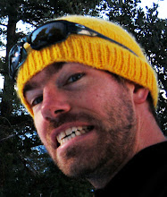
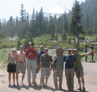
Thursday- Met our guides (Kirah and Logan) and rest of our group (Tim, Pat, Matt, Darin, Evan, and Steve) at the 5th season store. We did a gear check there and then caravaned over to the North Gate Trail head which was an hour away. Around 1pm we hiked from the North Gate Trail Head (6900ft) to our base camp at 9800 feet. It was a good 5 hr hike in with heavy packs. I don't think I have ever carried such a heavy pack before. I think mine was close to 50 pounds. When we got to base camp we set up our tents and ate burritos prepared by Logan and Kirah. Throughout the trip our guides provided dinner and breakfast...good stuff. Around 8 we finished dinner and watched the sunset. I was able to shoot a little with my SLR. The only shot I really liked is the one at the top of this blog entry.

Friday- was a mellow day. We woke up late (7 ish) had some bagels and ham and packed up our gear to do some training on the near by snow field. The snow was "punchy" so we didn't get a good feel for our crampons. We put them on for a minute or so but then took them off, so my first real use of crampons was on the summit climb Friday. After taking off the crampons, Logan showed us the cross over step which is a crucial climbing technique with crampons on. He also went over the duck step and one more I forget the name of. After the climbing techniques we busted out the the ice axes and Kirah showed us how to self arrest. We practice many different scenarios in which we needed to self arrest. The last part of training that day was setting anchors, ropes and knots for belaying and rappelling. Cary and I set snow anchors by burying my ice axe in the snow. It was quite remarkable what could be buried as a snow anchor, a water bottle, snickers bar, even a carabeaner worked! After training we headed back to camp around 3. That evening we ate an early dinner around 4:30 because we had to get up at 1:30 am for our summit bid the next day. Logan and Kirah prepared smoked cheese and broccoli soup and mac and cheese with basil. After dinner we packed our bags for the summit bid and went to bed( no one really slept that night, mostly just lying down resting).

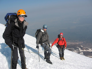
Saturday-At 1:30 am we got out of our tents and got ready for the climb. We had tea and oatmeal and discussed the plan for the climb. At 2:30 we took off and climbed up the Hotlum/Bolum ridge. At 4:45 we reached the first snow bank where we had to put on crampons. I was a little nervous but after about 5 minutes and one traverse I felt comfortable. I used the crossover step technique we learned the previous day. That helped alleviate the strain of crampons on my legs. We used crampons and ice axes for the next 3.5 hours. The last couple of hours consisted of scrambling up scree and also 3rd class rock scramble. At around 10:30 we summitted at the north summit and then walked over to the south summit which is the highest summit. We only stayed long enough to take pictures, sign the register and eat a cliff bar(about 15 minutes). Coming down we didn't need crampons. The weather was nice and warm and started making the snow mushy. I led my group (Caren, Pat, and Kirah) down the snow slopes. On the way down we post holed up to our mid thighs. We got plenty of chances to self arrest (nothing serious since we were roped together) that made for good experience. Kirah had to go on "operation water bottle" when a water bottle fell down the snow bank. Once we got back to the ridge we walked a little ways until we hit a snow patch where we glissaded down to our camp site. I eventually got back to our base camp around 2:30. I was tired but completely stoked on climbing the mountain with my team. That afternoon we all chilled and shared stories. For dinner we had the "Thanksgiving feast" which consisted of mashed potatoes, gravy, cranberry sauce, stuffing, tofu, butter, and herbs. I mushed it all together in my cup and scarfed it down. It was an early night for us that night. After dinner we talked about poo stories (don't ask!) and the hilarious pee funnel story Kirah told from her climb on Denali....."I've seen stranger things in my sleeping bag!"

Sunday- We packed up our gear, ate pancakes and practiced "climber heist" knots. Logan set up a rope and we got our harnesses on and practiced a technique of climbing out of a crevasse on a fix rope. We tied 2 climber heists with our cordeletts(shorts ropes) and climbed up the rope. Around 10:30 we headed back to the North Gate trail head. We got back around 12:30. From there we drove back to the town of Shasta, returned gear and went out to a tavern to eat lunch and have a few beers. The first beer was free to the people who summitted...pretty cool! Later on Cary and I went to A-1 Choice Inn motel and checked in and quickly jumped in the pool. Damn that felt good! Later on that night we caught a movie and went out for pizza.

Monday- We got up at 5:30 checked out of the motel and hit up Seven Suns Cafe. This was the local cafe place in Shasta. It has very good grub and great ice tea. Then we headed back on our 9 hour drive back to Los Angeles.

Reflection- It is hard to put a value on a trip/climb like this one. It is very interesting bonding with strangers coming together to climb a mountain for different reasons. Needless to say I had a great time. I was very fortunate to be in good health and have a great climbing team of Caren, Tim and Kirah. I also value conversations around base camp watching the sunset and drinking beer with the group reminiscing about our adventure. Climbing to the summit was great but that was only part of the fun and thrilling adventure I had on this trip. My goal of climbing the 15 14,000ft peaks in California is very much alive. I really want to pursue alpine climbing. Using crampons and an ice axe was spectacular and I look forward to using these skills I have just learned (with much more experience needed) to continue climbing peaks in the snow.

As for now my next major climb is Mt. Langley (another 14er) next month. This, however, doesn't involve alpine climbing but I still look forward to climbing a peak with sierra club members I don't know yet but will form the odd, but special bond of climbing a peak together.

Good times!

Trip Notes:
  • Trailhead: 6900 feet
  • Base Camp: 9800 feet
  • Summit: 14,100 feet
  • Summit climb from base camp: 8hrs up / 4 hrs down
  • Blister count after climb: 4 on feet and 2 on hands
  • Guide service: Shasta Mountain Guides


Tuesday, July 1, 2008

Melis makes the blog!


I know it is a little late but 2 weeks ago Melis and I hiked the bridge to nowhere hike with our friend Anneke.  Unfortunately, we had to turn around before the bridge due to time constraints.  It was a great hike and great to get out on the trails with Melis and Anneke.

I can't wait to tell Melis that she made the blog.  Haha :-)

Thursday, June 19, 2008

1 week until Mt. Shasta!

Well, I have one more week until  Cary and I embark on our 4 day mountaineering class/climb up Mt. Shasta.  We will be driving up Wednesday camping out that night and starting up the mountain Thursday morning.  This is  a 4 day mountaineering course that focuses on mountaineering skills such as using crampons, ice axes, snow anchors, belaying, glacier travel, alpine climbing, etc.  I think the plan is to climb to base camp (north side glaciers) and for 2 days learn these specific skills for our alpine summit bid Sat or Sun.  We should return to the base of the mountain Sunday afternoon.

I am really excited about this, however,  I have been sick the past three days and I hope that I can recover before we leave.  I haven't exercised in 4 days and don't think I will for the next few days until I feel 100% again.  During this time I have been trying to get alot of rest.  That being said I picked up the book "3 Cups of Tea" recommended by my mom and melis.  It is about  a mountaineer who attempts to climb K2 and gets lost coming down.  He stumbles upon a village that has no educational facilities.  He (Greg Mortenson) falls in love with the people of this small village (Korphe) and builds a school for them.  The book continues with Mortenson's journey to build schools for needy villages.  This particularly caught my attention right away since it combines my passion for climbing mountains and education.  I am half way through it right now and love it.  This is helping me pass the time while trying to rest and get well.

Monday, June 9, 2008

Mt. San Jacinto

On Sunday my buddy Cary and I took the ariel tram up to Round Valley and hiked up to San Jacinto Peak. This is the easiest route to the top, however, still quite a work out for me. It was a beautiful day, the sun was out and there was even a little snow on the trail as well. Down in Palm Springs it was 102 degrees out but up on the mountain (8400 feet high) it was a nice 70 degrees. Cary and I look forward to doing some snow camping up there in the winter time. It should be perfect for snow shoeing, photography and camping as well. The view at the top was spectacular. I think my favorite part was looking down of the windmill farms just off hwy 10.

Next time I do this hike I will start from Idyllwild and trek to the summit in a day or maybe turn it into a backpack trip. It is about 15 miles round trip with 4-6 thousand feet elevation gain. We ran into a few people doing it as a 1 night trip and they said it was awesome.

The tram costs 21 dollars for a round trip ticket. It took about 10 minutes to get up the mountain (8400 feet). Tram runs every half hour. There is a general store and restaurant at the top for food if need be.

Trip info:
  • Start 8:30 (reached summit @ 12, took a 15minute break)
  • End 2:30
  • Elevation start 8400
  • Elevation Summit 10800
  • 11 Miles (round trip)


Wednesday, June 4, 2008

Funny video

This video was made by one of my animation students. In it it depicts me and him in class. This just cracks me up. I was very impressed.

Friday, May 30, 2008

Brown Mountain Road--Mountain Biking


Yesterday I went mountain biking in the San Gabriel Mountains. I road the Brown Mountain Trail (a dirt fire road) near JPL. I haven't been mountain biking lately and I really would like to get back into it. I have done this trail before. I parked in the parking lot above JPL (Secco Rd?) and started my ride crossing a closed fire road gate. The ride is about 3.5 miles from the parking lot. I originally tried another trail (to the right of Brown Mt.) but the bridge had collapsed and they closed the trail. Brown Mountain is a steady incline for about 3 miles. This is an excellent work out, which I am in need of for training for Mt. Shasta this June. Anyhoo, I will try to ride a little farther each time. The climb kicked my butt but the ride down (all down hill basically) was awesome.

Check out my video! You can also see the path I took in Google maps or download the KML file to your Google Earth.

Riding stats:

Distance: 8 miles RT
Time: 50 minutes up 10 minutes down


View Larger Map

Tuesday, May 27, 2008

Mt. Baldy


Today my buddy Cary and I hiked up Mt. Baldy. It was a beautiful day. There some snow left over from the storm a few days ago which made the mountain landscape that much better. We hiked from Manker Flat to Baldy Notch, Devils Backbone, and to the top of Mt. San Antonio(referred to as Mt. Baldy). The hike was 6 miles each way. The first 3 miles were on a fire road until we hit Baldy Notch (ski lifts). The Devils Backbone was more of a traditional trail, steep at some points. Since there was some snow we post holed a little but mostly went through sloshy snow. The clouds were hanging low and at about 8000 feet up we were above the cloud line giving us spectacular views! The weather and views were amazing. I have hiked this in the summer time without any snow but it just doesn't compare with the great white stuff!

Below is our route according to my GPS tracks.

This is a good local hike for training for Mt. Shasta. The summit is 10,000 feet. Oh, I also ran into one of the WTC leaders (edee) at the top.

Trip info:
  • Start: 8:30 summit @ 12:50 (15 minute break at the top)
  • End: 4:15
  • Total Miles: 12
  • Elevation start: 6100
  • Elevation @ summit: 10064
  • Total Elevation Gain: 3964


View Larger Map